The birds and the trees: Scientists use remote sensing data to help explain patterns of life
Like watching a familiar play, but this time from the balcony and with a new set of binoculars, satellite remote sensing technology is giving Michigan State University researchers a powerful lens to view landscapes that set the stage for earth's biodiversity.
"Geodiversity, or the variations in abiotic processes and features of the landscape such as landmarks, topography and unique soil types, have yet to be quantified at different scales in the United States," said Phoebe Zarnetske, assistant professor in the Department of Integrative Biology and the Ecology, Evolution, and Behavior Program and principal investigator of the project. "We wanted to know if, thanks to advances in satellite remote sensing, we could measure geodiversity in a new way and align it with already established patterns of biodiversity.
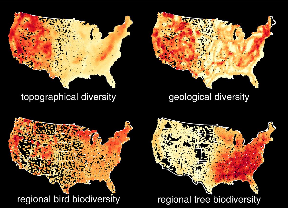
"We are especially interested in the scales at which geodiversity and biodiversity relate most closely," Zarnetske continued. "Is geodiversity more closely related with biodiversity at fine resolutions, at a plot scale for example, or does it correlate better if we zoom out to a larger area?"
As lead of MSU's Spatial and Community Ecology Lab (SpaCE Lab), Zarnetske and her team used open source data from NASA satellites to conduct the innovative research recently highlighted in two landmark papers, "Beyond counts and averages: Relating geodiversity to dimensions of biodiversity" and "Towards connecting biodiversity and geodiversity across scales with satellite remote sensing," both published in the journal Global Ecology and Biogeography. " We would expect that places with more habitat variability provide more unique opportunities for more species, and thus foster higher levels of biodiversity," Zarnetske said. "But this relationship is likely to depend on the type of geodiversity, the type of organism, how we measure biodiversity and the scale of the analysis."
Zarnetske, along with former MSU postdoctoral researcher Quentin Read and a team of scientists involved in the NASA-funded working group, tackled the monumental task of quantifying geodiversity variables at different scales, from plot size up to 100 km across, by applying a "ruggedness" index in novel ways.
Read more at MSU Today.